top of page


3D Building Model
3D building model created using Revit
 Semi-detachment Three Bedroom House |
|---|
 Site PlanThe site plan was generated converting a shape file (GIS format) to AutoCAD (dwg) format. The rendering was achieved using a open source image manipulation application (GIMP). |
 Ground Floor PlanExample of technical illustrations created for the Groundwater Newsletter (July 2014) using CorDRAW |
 First Floor Plan |
 Section View (A-A) |
 Front Elevation |
 Rear Elevation |
 Essex BridgeExample of digitizing scanned document |
 2D - Lathe Tool PostPart drawing and assembly of a lathe tool post generated with AutoCAD |
|---|
 Lathe Tool PostExample of Assembly create with AutoCAD |
 3D - Lathe Tool PostPart drawing and assembly of a lathe tool post generated with AutoCAD |
 Control Handle AssemblyAssembly of a control handle created using AutoCAD |
|---|
 HandlePart drawing created using AutoCAD |
 PivotPart drawing created using AutoCAD |
 BodyPart drawing created using AutoCAD |
 CollarPart drawing created using AutoCAD |
 Pressed Grease CapSolid Modelling with AutoCAD |
|---|
 Anchor Block |
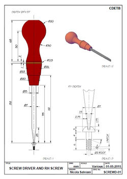 Screw Driver and RH ScrewDrawing realized using AutoCAD |
 Solid Modelling StudyAutoCAD |
 LogoPNG created from a CAD drawing. Image enhancement achieved using GIMP |
 Mill and Broach Test Piece |
|---|
 Boiler Stay Bracket |
 Boiler Stay Bracket |
 Pivot Bracket |
 Anchor Plate |
 Boiler Stay Bracket |
 Boiler Stay Bracket |
 Pump Body |
|---|
 Pump Body - 3D |
 3D Hydrogeological Block Diagram3D surface model created in ArcGIS using a Digital Elevation Model (DEM). |  Core-Logging.pngExample of layout document and photo retouching using CorelDRAW |  Pumping TestExample of technical illustrations created for the Groundwater Newsletter (July 2014) using CorDRAW |
|---|---|---|
 Hydrogeological Conceptual Model3D Surface model generated in ArcScene using a DEM. Drawing crreated using CorelDRAW |  Hydrogeological ModelProfile created using ArcGIS. Image generated using CorelDRAW |  Hydrogeological Conceptual ModelProfile created using ArcGIS. Image generated using CorelDRAW |
 Zone Of Contribution (ZOC) MapMap generated using ArcGIS |  Location MapMap generated using ArcGIS. |


Nicola Salviani
16 Glengarriff Parade
Dublin 7, Ireland
Tel: +353 89 207 7333
bottom of page